tranmerc
Transverse Mercator Projection
Classification
Cylindrical
Identifier
tranmerc
Features
This conformal projection is the transverse form of the Mercator projection and is also known as the Gauss-Krueger projection. It is not equal area, equidistant, or perspective.
The scale is constant along the central meridian, and increases to the east and west. The scale at the central meridian can be set true to scale, or reduced slightly to render the mean scale of the overall map more correctly.
Remarks
The uniformity of scale along its central meridian makes transverse Mercator an excellent choice for mapping areas that are elongated north-to-south. Its best known application is the definition of Universal Transverse Mercator (UTM) coordinates. Each UTM zone spans only 6 degrees of longitude, but the northern half extends from the equator all the way to 84 degrees north and the southern half extends from 80 degrees south to the equator. Other map grids based on transverse Mercator include many of the state plane zones in the US and the UK National Grid.
Mapping Toolbox™ uses a different implementation of the transverse Mercator projection for displaying coordinates on
axesm-based maps than for projecting coordinates using theprojfwdorprojinvfunction. These implementations may produce differing results.
Example
landareas = shaperead('landareas.shp','UseGeoCoords',true);
axesm ('tranmerc', 'Frame', 'on', 'Grid', 'on');
geoshow(landareas,'FaceColor',[1 1 .5],'EdgeColor',[.6 .6 .6]);
tissot;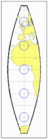
Version History
Introduced before R2006a