pcarree
Plate Carree Projection
Classification
Cylindrical
Identifier
pcarree
Graticule
Meridians: Equally spaced straight parallel lines half as long as the Equator.
Parallels: Equally spaced straight parallel lines, perpendicular to and having the same spacing as the meridians.
Poles: Straight lines equal in length to the Equator.
Symmetry: About any meridian or the Equator.
Features
This is a projection onto a cylinder tangent at the Equator. Distortion of both shape and area increases with distance from the Equator. Scale is true along all meridians (i.e., it is equidistant) and the Equator and is constant along any parallel and along the parallel of opposite sign.
Parallels
For cylindrical projections, only one standard parallel is specified. The other standard parallel is the same latitude with the opposite sign. For this projection, the standard parallel is by definition fixed at 0º.
Remarks
This projection, like the more general Equidistant Cylindrical, is credited to Marinus of Tyre, thought to have invented it about A.D. 100. It may, in fact, have been originated by Erastosthenes, who lived approximately 275–195 B.C. The Plate Carrée has the most simply constructed graticule of any projection. It was used frequently in the 15th and 16th centuries and is quite common today in very simple computer mapping programs. It is the simplest and limiting form of the Equidistant Cylindrical projection. Another name for the Plate Carrée projection is the Simple Cylindrical. Its transverse aspect is the Cassini projection.
On the sphere, this projection can have an arbitrary, oblique aspect, as controlled by the
Originproperty of theaxesm-based map. On the ellipsoid, only the equatorial aspect is supported.
Example
landareas = shaperead('landareas.shp','UseGeoCoords',true);
axesm ('pcarree', 'Frame', 'on', 'Grid', 'on');
geoshow(landareas,'FaceColor',[1 1 .5],'EdgeColor',[.6 .6 .6]);
tissot;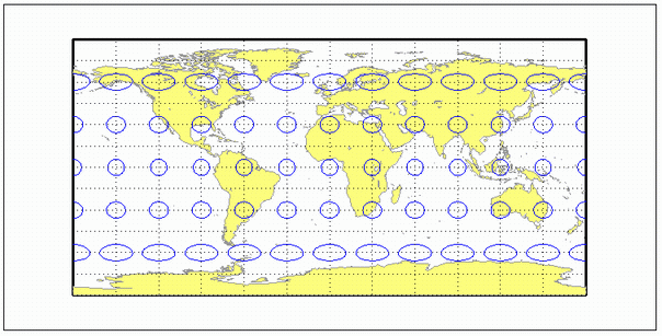
Version History
Introduced before R2006a