mbtileswrite
Description
mbtileswrite(
writes the specified georeferenced image or data grid to an MBTiles file. Specify the image or
data grid using an array and a raster reference object. The input image or data grid must be
referenced to Earth.filename,A,R)
When combined with the addCustomBasemap
function, the mbtileswrite function enables you to add custom basemaps
that can be used in offline environments.
mbtileswrite(
specifies additional options using one or more name-value arguments. For example, you can
write an attribution or description to the file.filename,A,R,Name=Value)
Examples
Create an MBTiles file using imagery stored in a GeoTIFF file. Then, use the MBTiles file to add a custom basemap.
Read a GeoTIFF file containing imagery of Boston into the workspace as an array and a map cells reference object. The array is a grid of cells referenced to projected coordinates.
[A,R] = readgeoraster("boston.tif");Write the imagery to an MBTiles file. Then, use the MBTiles file to add a custom basemap. The addCustomBasemap function issues a warning because the MBTiles file does not contain global data for zoom level 0.
filename = "boston.mbtiles";
mbtileswrite(filename,A,R)
addCustomBasemap("bostonBasemap",filename)
Warning: Basemap contains regional data with latitude limits in the range [42.3451, 42.3713] and longitude limits in the range [-71.0999, -71.0454]. Global map displays might show missing tiles.
Display the custom basemap using a geographic axes. MATLAB® sets the limits of the axes to closely match the limits of the basemap data. The black background indicates areas where the basemap tile contains no data.
figure
geobasemap bostonBasemap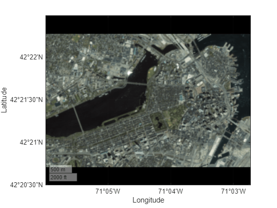
To create an MBTiles file that contains full-color tiles from quantitative data, you must first convert the data to an indexed image and a colormap, and then convert the indexed image and colormap to an RGB image.
Search the Web Map Service (WMS) Database for a layer containing terrain elevation data from the WMS server hosted by MathWorks®. The elevation data is derived from GMTED2010.
layers = wmsfind("mathworks",SearchField="serverurl");
elevation = refine(layers,"elevation");
Read global elevation data from the server. Specify the raster size as 2048-by-4096, and specify the format as BIL. The wmsread function represents the data using an array and a geographic cells reference object.
[Z,R] = wmsread(elevation,Latlim=[-90 90],Lonlim=[-180 180], ...
    ImageHeight=2048,ImageWidth=4096,ImageFormat="image/bil");
Convert the elevation data to an indexed image and a colormap. An indexed image is an array of integers, where each integer maps to a row of the colormap. Each row of the colormap is an RGB triplet that specifies the red, green, and blue components of a color.
Prepare to visualize the water areas in blue by setting elevations at or below sea level (
Z <= 0) to a value below sea level.Specify the number of colors to include in the colormap as 256.
Create a colormap that is appropriate for elevation data.
Rescale the elevation data to the interval [0, 255].
Create the indexed image by converting the rescaled elevation data to an array of 16-bit unsigned integers. Note that the largest value of the unsigned integer type must be greater than the number of colors in the colormap.
% create colormap
Z(Z <= 0) = -1;
numColors = 256;
cmap = demcmap(Z,numColors);

% create indexed image
X = rescale(Z,0,numColors-1);
X = uint16(X);
Convert the indexed image to an RGB image of 8-bit unsigned integers.
rgb = ind2rgb8(X,cmap);
Write the RGB image and reference object to an MBTiles file. Add an attribution to the file by using the Attribution name-value argument.
mbtileswrite("gmted2010.mbtiles",rgb,R,Attribution="US Geological Survey")
Use the MBTiles file to add a custom basemap.
addCustomBasemap("gmted2010","gmted2010.mbtiles")
Create a geographic globe that uses the custom basemap. Position the camera above South America.
uif = uifigure;
g = geoglobe(uif,Basemap="gmted2010");

campos(g,-18,-62)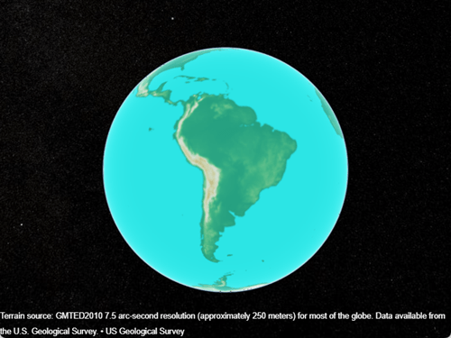
Input Arguments
Name-Value Arguments
More About
Algorithms
The mbtileswrite function writes MBTiles files using version 1.1 of
the MBTiles specification.
Alternative Functionality
The mbtileswrite function enables you to store and share map tiles.
If you do not need to store or share the map tiles, then you can add a custom basemap directly
from an array and a raster reference object by using the addCustomBasemap
function.
Version History
Introduced in R2024b