extractEigenFeatures
Extract eigenvalue-based features from point cloud segments
Syntax
Description
features = extractEigenFeatures(ptCloud,labels)labels, that correspond to the segmented point cloud.
Eigenvalue-based features characterize geometrical features of point cloud segments. These features can be used in simultaneous localization and mapping (SLAM) applications for loop closure detection and localization in a target map.
features = extractEigenFeatures(segmentsIn)segmentsIn. Use this syntax to facilitate the selection of
specific segments in a point cloud scan for local feature extraction.
[
additionally returns the segments extracted from the input point cloud using any
combination of arguments from previous syntaxes. Use this syntax to facilitate
visualization of the segments.features,segmentsOut] = extractEigenFeatures(___)
[___] = extractEigenFeatures(___,NormalizeEigenvalues=tf)
normalizes the eigenvalues prior to computing features, specified as
true or false. Set tf to
true when the next step is to use a classifier to assign a semantic
label to a 3-D point. Set tf to false when the next
step is to find matching features. The default value is false.
Examples
Load an organized lidar point cloud.
ld = load('drivingLidarPoints.mat');
ptCloud = ld.ptCloud;
Segment and remove the ground plane.
groundPtsIdx = segmentGroundFromLidarData(ptCloud,'ElevationAngleDelta',15);
ptCloud = select(ptCloud,~groundPtsIdx,'OutputSize','full');
Cluster the remaining points with a minimum of 50 points per cluster.
distThreshold = 0.5; % in meters
minPoints = 50;
[labels,numClusters] = segmentLidarData(ptCloud,distThreshold,'NumClusterPoints',minPoints);
Compute eigenvalue-based features.
features = extractEigenFeatures(ptCloud,labels,'NormalizeEigenvalues',true)features=17×1 eigenFeature array with properties:
Feature
Centroid
⋮
Create a Velodyne® PCAP file reader.
veloReader = velodyneFileReader('lidarData_ConstructionRoad.pcap','HDL32E');
Read the first and fourth scans from the file.
ptCloud1 = readFrame(veloReader,1);
ptCloud2 = readFrame(veloReader,4);
Remove the ground plane from the scans.
maxDistance = 1; % in meters
referenceVector = [0 0 1];
[~,~,selectIdx] = pcfitplane(ptCloud1,maxDistance,referenceVector);
ptCloud1 = select(ptCloud1,selectIdx,'OutputSize','full');
[~,~,selectIdx] = pcfitplane(ptCloud2,maxDistance,referenceVector);
ptCloud2 = select(ptCloud2,selectIdx,'OutputSize','full');
Cluster the point clouds with a minimum of 10 points per cluster using the exhaustive method.
minDistance = 2; % in meters
minPoints = 10;
labels1 = pcsegdist(ptCloud1,minDistance,'NumClusterPoints',minPoints,'Method','exhaustive');
labels2 = pcsegdist(ptCloud2,minDistance,'NumClusterPoints',minPoints,'Method','exhaustive');
Extract eigen-value features and the corresponding segments from each point cloud.
[eigFeatures1,segments1] = extractEigenFeatures(ptCloud1,labels1);
[eigFeatures2,segments2] = extractEigenFeatures(ptCloud2,labels2);
Create matrices of the features and centroids extracted from each point cloud, for matching.
features1 = vertcat(eigFeatures1.Feature);
features2 = vertcat(eigFeatures2.Feature);
centroids1 = vertcat(eigFeatures1.Centroid);
centroids2 = vertcat(eigFeatures2.Centroid);
Find putative feature matches.
indexPairs = pcmatchfeatures(features1,features2, ...
    pointCloud(centroids1),pointCloud(centroids2));
Get the matched segments and features for visualization.
matchedSegments1 = segments1(indexPairs(:,1));
matchedSegments2 = segments2(indexPairs(:,2));
matchedFeatures1 = eigFeatures1(indexPairs(:,1));
matchedFeatures2 = eigFeatures2(indexPairs(:,2));
Visualize the matches.
figure
pcshowMatchedFeatures(matchedSegments1,matchedSegments2,matchedFeatures1,matchedFeatures2)
title('Matched Segments')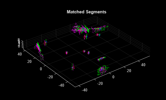
Input Arguments
Output Arguments
References
[1] Weinmann, M., B. Jutzi, and C. Mallet. “Semantic 3D Scene Interpretation: A Framework Combining Optimal Neighborhood Size Selection with Relevant Features.” ISPRS Annals of Photogrammetry, Remote Sensing and Spatial Information Sciences II–3 (August 7, 2014): 181–88. https://doi.org/10.5194/isprsannals-II-3-181-2014.
Version History
Introduced in R2021a